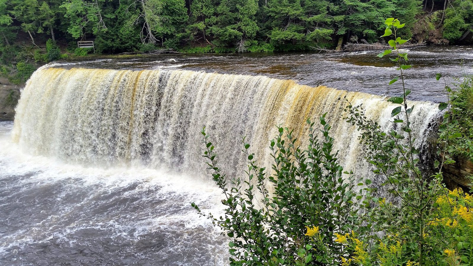
The first thing that surprises people at Tahquamenon Falls is the color. The Tahquamenon River pours over the Upper Falls in a curtain more than 200 feet wide, and the water is the brown of strong tea or root beer, with a head of cream-colored foam churning at the bottom. The second surprise is the noise: on a spring day, when snowmelt pushes the flow toward 50,000 gallons a second, you hear the falls long before you see them through the hemlocks. They sit in the eastern Upper Peninsula near Paradise, about five and a half hours north of Detroit, and they anchor one of the best short road trips in Michigan: the loop through Paradise, Whitefish Point and Sault Ste. Marie.
The short answer: Tahquamenon Falls State Park has two sets of falls four miles apart. The Upper Falls is the big one, about 48 feet high and more than 200 feet wide, now reached by a new accessible boardwalk; the Lower Falls is a set of smaller cascades around an island you can visit by bridge or rowboat. A Recreation Passport covers entry (non-residents $12 a day or $42 a year in 2026). See both in half a day, and add Whitefish Point’s shipwreck museum and the Soo Locks for a full weekend.
Fees, hours, trail details and campground rules below were checked on September 23, 2026 against the Michigan DNR’s park pages and the other attractions’ own websites. The Toonerville Trolley, the old train-and-riverboat trip to the falls, has closed; many older guides still list it.
On this page: At a glance · Upper vs Lower Falls · Why it’s brown · What it costs · Time needed · The Upper Falls · The Lower Falls · The River Trail · Camping and the lodge · Paddling and fishing · Winter · Photography · With kids · Accessibility · Best time to go · Where to eat · Where to stay · The eastern U.P. loop · Getting there · Checklist · Safety · Is it worth it? · What to skip · FAQ
Tahquamenon Falls at a glance
| Question | Answer (checked September 2026) |
|---|---|
| Where is it? | Tahquamenon Falls State Park, eastern U.P., on M-123 west of Paradise in Chippewa and Luce counties |
| How big is the Upper Falls? | About a 48-foot drop, more than 200 feet wide; average flow about 7,000 gallons a second, up to 50,000 in spring runoff |
| Lower Falls | Four miles downstream: a series of smaller cascades around an island |
| Entry | Recreation Passport on the vehicle: Michigan residents $15 a year with plate renewal; non-residents $12 a day or $42 a year (2026) |
| Accessibility | New 1,100-foot accessible boardwalk to the Upper Falls brink; accessible platforms at both falls; free track chair to borrow |
| Between the falls | 4-mile River Trail (8 miles round trip); fee-based Hunter Shuttle in summer; 5 miles by road |
| Food | Tahquamenon Falls Brewery & Pub at the Upper Falls; cafe and gift shop at the Lower Falls |
| Dogs | Allowed on all trails and viewing platforms on a 6-foot leash |
| Open | Year-round; winter ski and snowshoe trails at the Upper Falls |
| Best time | Late May and early June for the water; the first two weeks of October for color; early August is the busiest |
| Park size | About 46,000 acres, Michigan’s second-largest state park |
| Drive from | Detroit about 5 h 45 to the Upper Falls, Grand Rapids about 5 h 10, Chicago about 8 h |
| Nearest towns | Paradise (about 20 minutes), Newberry (about 30 minutes), Sault Ste. Marie (about 1 h 30) |
Which is better, Upper or Lower Tahquamenon Falls?
They’re different kinds of waterfall, and most visitors should see both; they’re only a 13-minute drive apart. The Upper Falls is the headline: one wide, single drop of amber water that you watch from platforms above and beside it. The Lower Falls is a cluster of smaller cascades split by an island, lower and less dramatic but more interactive, since you can walk around the island or row out to it. If you only have an hour, see the Upper Falls. If you have children, the Lower Falls island is the part they’ll remember.
| Upper Falls | Lower Falls | |
|---|---|---|
| What it is | A single drop of about 48 feet, more than 200 feet wide | A series of smaller cascades around an island |
| Walk from parking | A paved path to three accessible viewing platforms; a 1,100-foot accessible boardwalk down to the brink | A short walk to a viewing platform; a half-mile accessible boardwalk along the river |
| Stairs | The old 94-step brink stairway has been replaced by the boardwalk; 116 steps down to the gorge viewing platform | Few; the boardwalk and island bridge are the main routes |
| Getting closer | The brink platform puts you right at the edge of the drop | Cross the Ronald A. Olson Island Bridge, or rent a rowboat to the island |
| Food and drink | Tahquamenon Falls Brewery & Pub | Lower Tahquamenon Falls Cafe & Gift Shop |
| Camping nearby | No campground at the falls; the park lodge is between the falls | The Lower Falls Modern Campground (188 sites) |
| Time needed | 1 to 1.5 hours | 1 to 2 hours, more with a rowboat |
Why is Tahquamenon Falls brown?
The color comes from tannins, the same compounds that color tea. The Tahquamenon River drains a huge area of cedar, spruce and hemlock swamps, and rain and snowmelt soak through the decaying needles and peat before reaching the river, carrying tannins with them. The water isn’t dirty or polluted; it’s simply stained. The river’s soft water also foams easily as it churns at the base of the falls, which is why you see the heavy, cream-colored froth that people sometimes mistake for soap.
The river is big, too. On an average day about 7,000 gallons a second go over the Upper Falls, and during spring snowmelt that can rise to about 50,000 gallons a second. The river also has a literary claim: Longfellow’s Song of Hiawatha has Hiawatha building his canoe “by the rushing Taquamenaw,” and the name turns up on signs and businesses all over the area.
The river’s history
The Tahquamenon has been a travel route for much longer than it’s been a tourist sight. The Anishinaabe, the Ojibwe people of the eastern U.P., fished and traveled the river and Whitefish Bay, and the falls were a landmark on the way inland. In the lumber boom of the late 1800s, loggers cut the white pine along its banks and floated the logs downriver to the mills, which is why the old-growth stands that survive near the Upper Falls are so valued today. The state later bought up the land around the falls, and the park has grown into one of the largest in Michigan, second only to the Porcupine Mountains.
How much does it cost to get into Tahquamenon Falls?
There’s no separate admission. Like every Michigan state park, Tahquamenon requires a Recreation Passport on each vehicle, and that covers both falls, the trails and the day-use areas.
| Item | 2026 cost |
|---|---|
| Recreation Passport, Michigan resident | $15 a year, bought with your license plate renewal (plus $5 if bought separately) |
| Recreation Passport, non-resident | $12 a day, or $42 for an annual pass valid through December 31 |
| Hunter Shuttle between the falls | Fee-based; book online or call or text 906-291-3422 |
| Rowboat to the Lower Falls island | Rented by the Lower Falls cafe, Memorial Day weekend to mid-October, conditions allowing |
| Campsites, backcountry sites and the lodge | Priced per night on MIDNRReservations.com |
| Sanitation station, non-campers | $10 |
| Mackinac Bridge toll on the way north | $4.00 per passenger vehicle |
For non-residents, the math is simple: if you’ll be in any Michigan state park on four or more days this year, the $42 annual pass costs less than daily passes, and it covers Kitch-iti-kipi, Mackinac Island State Park’s roads and trails, and every other state park on your trip.
How much time do you need?
Plan on half a day to see both falls properly: an hour to an hour and a half at the Upper Falls, including the boardwalk and the gorge stairs, a 13-minute drive, and an hour or two at the Lower Falls, longer if you rent a rowboat or eat at the pub or cafe. Add three to four hours if you walk the River Trail one way and ride the shuttle back, or most of a day if you hike it both ways. For the whole eastern U.P. loop, with Whitefish Point, Paradise and the Soo Locks, two days is comfortable and three is relaxed. Remember the drive: the falls are about an hour and a half from both St. Ignace and Sault Ste. Marie, so a day trip from the Mackinac area means three hours in the car.
The Upper Falls
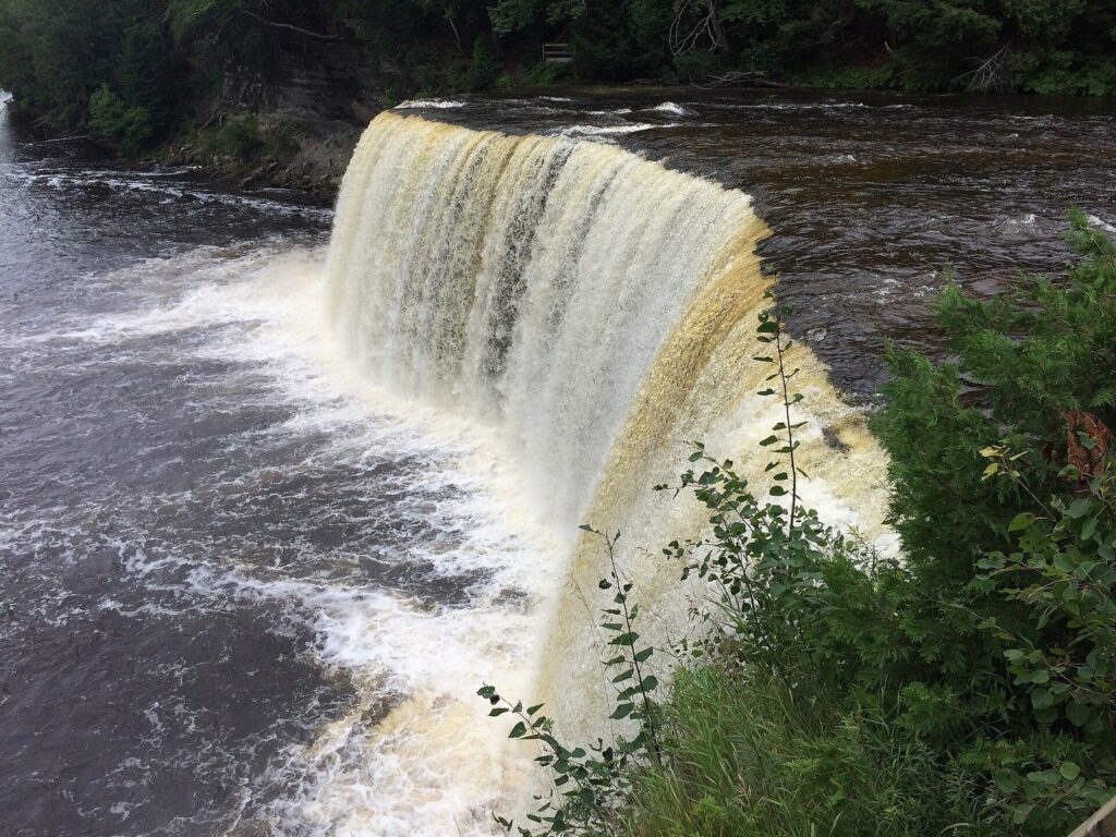
The Upper Falls day-use area, off M-123 about 14 miles west of Paradise, has a large parking lot, accessible restrooms, a picnic area and the Tahquamenon Falls Brewery & Pub, a privately owned restaurant and brewery inside the park. From the lot, a paved path leads through old-growth forest to three accessible viewing platforms along the gorge, with views of the falls from above and to the side.
The big change is the new boardwalk to the brink. For decades, reaching the edge of the falls meant 94 steps down an aging stairway. That’s been replaced by a 1,100-foot accessible boardwalk, paid for with about $1.5 million in federal relief funding and unveiled in spring 2026, that switchbacks down through old-growth forest to the brink platform, with five landings along the way offering benches, interpretive displays and new views of the river. A separate stairway of 116 steps leads down to the gorge viewing platform, lower and farther downstream, for the head-on view of the whole drop. Allow an hour to an hour and a half, more if you eat at the pub.
Photo tip: early mornings and overcast days soften the glare on the foam, and a slow shutter turns it to silk. Drones are prohibited on or above the viewing platforms.
The Lower Falls
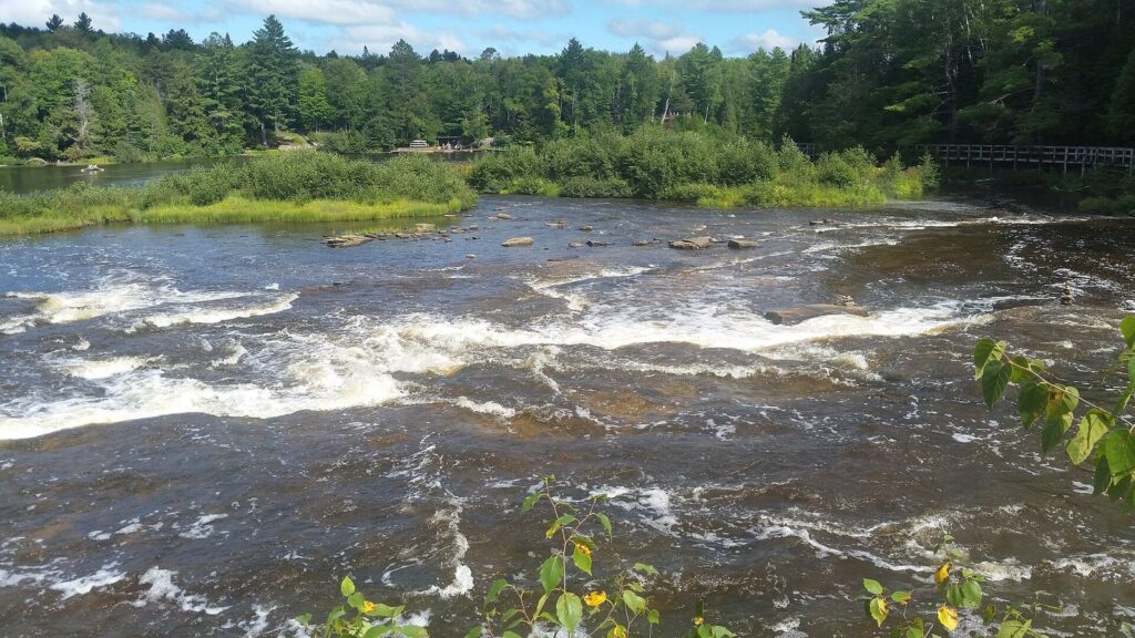
Four miles downstream, the river splits around an island and tumbles over a series of smaller falls and rapids. The Lower Falls day-use area has a short walk to a viewing platform, a half-mile accessible boardwalk along the river, a picnic pavilion and the Lower Tahquamenon Falls Cafe & Gift Shop. The best way to see it is from the island itself: cross the Ronald A. Olson Island Bridge on foot, or rent a rowboat from the cafe (Memorial Day weekend to mid-October, conditions allowing, no reservations) and row across the pool to the island, where a trail loops around past the cascades. On hot summer days people wade in the shallows on the island’s edges; stay out of the current near the drops, where the rock is slick.
The Lower Falls is also the park’s main hub for overnight visitors, with the big modern campground a short walk away and the canoe and kayak launch for the river below.
How long is the hike between the Upper and Lower Falls?
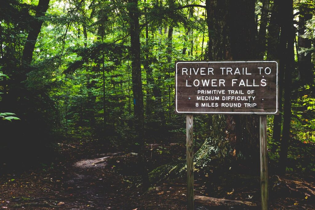
The River Trail follows the Tahquamenon between the two falls for about 4 miles one way, 8 miles round trip, and it’s part of the North Country Trail, which runs 16 miles through the park. It’s a primitive trail of medium difficulty: roots, some mud, short climbs and stairs, and the river in view much of the way through old-growth forest. Most hikers take two to three hours one way.
You don’t have to walk it both ways. The Hunter Shuttle Service runs a fee-based shuttle between the Upper and Lower Falls from noon to 8 p.m., on weekends through June 21 and daily from June 22 through Labor Day; book online or call or text 906-291-3422. Park at one end, ride the shuttle, and hike back to your car. Carry water, bug spray (June is black-fly season) and a map; black bears live in the park, so keep food packed away.
The park has more than 35 miles of trails in all, including the Giant Pines Loop near the Upper Falls, which becomes a groomed ski trail in winter, and three reservable backcountry campsites near the North Country Trail for an overnight.
Other trails in the park
Beyond the River Trail, the park’s 35-plus miles of trail include the Giant Pines Loop near the Upper Falls, about 3.8 miles through some of the park’s biggest old-growth pines and hemlocks, and the shorter 1-mile Lantern Loop; both are groomed for cross-country skiing in winter. The North Country Trail continues beyond the falls through remote swamp and forest, and the park’s three backcountry campsites sit along or near it, 1 to 5 miles from the nearest parking. For a short walk with children, the paved paths and boardwalks at both falls are enough to see the highlights.
Camping and the park lodge
Tahquamenon has four campgrounds and a lodge. All need a Recreation Passport on the vehicle, and summer weekends book up; reserve through MIDNRReservations.com.
| Where | Type | Details |
|---|---|---|
| Lower Falls Modern Campground | Modern, 188 sites in two loops | All sites 30-amp (some 50-amp). Hemlock loop, about a mile from the falls, is shadier and open year-round with a year-round shower building; Portage loop, a quarter-mile from the falls near the river, is sunnier, with some river views and hike-in camping in winter |
| Rivermouth Modern Campground | Modern | Wooded, 5 miles south of Paradise near where the river meets Whitefish Bay; accessible and pull-through sites |
| Rivermouth Rustic Campground | Semi-modern in season | On the river under red pines, with sunset views; water spigots mid-May to the second Sunday in October, then rustic |
| Backcountry sites | Primitive, 3 sites | Near the North Country Trail, 1 to 5 miles in; picnic table, fire ring and latrine; reservations required |
| Tahquamenon Falls Lodge | Lodge | Between the falls; sleeps 8 in three bedrooms with two bathrooms and a full kitchen; near the snowmobile trails |
Which to choose: Lower Falls if you want to walk to a waterfall from your tent; Rivermouth if you’d rather be on the river near Whitefish Bay, a short drive from Paradise and Whitefish Point; the lodge for a family group or a winter trip.
Paddling, fishing and wildlife
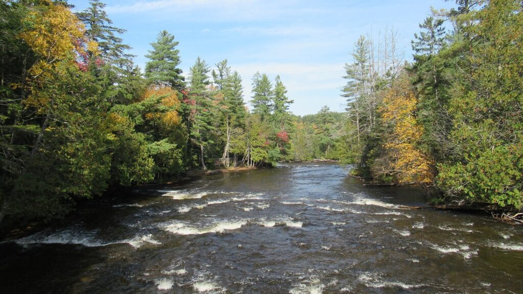
Below the Lower Falls, the Tahquamenon offers 17 miles of paddling to the Rivermouth, with a canoe and kayak launch at the Lower Falls day-use area and a carry-in site at the Rivermouth Modern Campground. The current is gentle enough that paddlers go both upstream and downstream. There’s an accessible paved boat launch near the Rivermouth, with limited parking, and a fishing pier across the road from the campground. Anglers catch brown trout, walleye, muskie, northern pike, yellow perch and smallmouth bass; you’ll need a Michigan fishing license.
The park is also one of the better places in Michigan to see a moose. They sometimes feed in the wet areas along M-123 between Paradise and the Lower Falls, especially early and late in the day, so drive that stretch slowly. Black bears, otters, beavers, foxes, porcupines, spruce grouse, pileated woodpeckers and bald eagles also live here. Seasonal naturalists run programs in summer and fall, and the park’s “Fact Shack” answers questions.
Is Tahquamenon Falls open in winter?
Yes, the park is open year-round, and winter is one of its best seasons. The falls don’t freeze solid, but ice builds up around the edges and on the gorge walls, and the amber water pouring between white ice and snow-covered hemlocks is a sight few people see. The Upper Falls day-use area stays open, with about 4 miles of groomed cross-country ski trails (the 1-mile Lantern Loop and the 3.8-mile Giant Pines Loop), 9 miles of marked snowshoe trails and backcountry skiing and snowshoeing throughout the park. Keep pets off the groomed ski tracks.
Snowmobilers reach the park on Trail 45, the Charcoal Grade Trail, a 44-mile route that connects to the M-123 Scenic Byway, with parking and trail access at both falls. The Hemlock loop of the Lower Falls campground stays open for winter camping, and the park lodge rents all year. Winter driving in the eastern U.P. means lake-effect snow off Lake Superior, so carry a winter kit and check the forecast; the Upper Falls paths can be icy, so wear traction cleats.
Photographing the falls
The best angles are easy to reach. At the Upper Falls, the new brink platform puts you beside the lip of the drop, looking across the curtain of water, and the gorge platform at the bottom of the 116 steps gives the full head-on view with the river below. At the Lower Falls, the best shots are from the island, looking back at the cascades on either side. Bright midday sun blows out the foam, so early morning, late afternoon and overcast days work better; a tripod and a slow shutter smooth the water, and a polarizing filter cuts the glare on wet rock. In fall, frame the falls with color from the platforms above, and in winter, go for the contrast of amber water and white ice. On the loop, Whitefish Point is best at sunrise and sunset, and at the Soo, the classic shot is a freighter in the Poe Lock with the International Bridge behind.
Tahquamenon Falls with kids
Tahquamenon is an easy park for families. The Upper Falls paths are paved and the new boardwalk is stroller-friendly, so even small children can see the brink without stairs. The Lower Falls is the fun part: walk the boardwalk, cross the island bridge or rent a rowboat, then let the kids splash in the calm shallows around the island, well away from the drops. Picnic areas at both day-use areas make lunch easy, both modern campgrounds have playgrounds, and the seasonal naturalist programs and the park’s Fact Shack are aimed at curious kids. Bring bug spray in June and early July, hold hands at the gorge overlooks, and keep snacks packed away from the park’s black bears.
Accessibility
Tahquamenon is one of Michigan’s most accessible big waterfalls. At the Upper Falls, a paved path leads to three accessible viewing platforms, the restrooms are ADA-accessible, and the new 1,100-foot boardwalk reaches the brink with switchbacks and five landings with benches. At the Lower Falls, a short walk leads to a viewing platform, and a half-mile accessible boardwalk follows the river. The park lends a track chair, an all-terrain wheelchair, free of charge. There are accessible picnic areas at both falls and at the Whitefish Bay picnic area, accessible fishing at the Rivermouth, an accessible paved boat launch, and ADA campsites at the Lower Falls and Rivermouth campgrounds. The 116-step gorge stairway and the River Trail aren’t accessible.
When is the best time to visit Tahquamenon Falls?
| Season | What it’s like |
|---|---|
| Spring (April to May) | The biggest flow of the year, up to about 50,000 gallons a second; cool, muddy trails and few people; the rowboats and shuttle don’t start until late May or June |
| Summer (June to August) | The busiest time, peaking in early August; everything open, including the shuttle and rowboats; black flies and mosquitoes in June and early July |
| Fall (September to mid-October) | Fall color around the falls, usually peaking in the eastern U.P. in early to mid-October; UP Travel’s 2026 outlook put the eastern counties’ peak in the second week of October |
| Winter (December to March) | Ice around the falls, cross-country skiing and snowshoeing, snowmobile access; very few visitors |
Our pick: late May or early June for the water and the quiet, or the first two weeks of October for color. In summer, go early in the morning or after 5 p.m. to avoid the midday crowd at the Upper Falls platforms.
Don’t cancel for rain. The falls are at their fullest after a wet spell, the platforms empty out, and the loop has good indoor stops: the Great Lakes Shipwreck Museum at Whitefish Point, the Soo Locks visitor center, and the brewery and cafe inside the park. Bring a rain shell and a cloth for your camera lens; the spray at the brink platform carries on a breeze.
Fall at the falls
The maples and birches around the falls turn red, orange and yellow against the dark hemlocks, and the amber water makes the color look even richer. The first two weeks of October are usually best in the eastern U.P., and weekends then are the park’s busiest outside summer. The Hunter Shuttle stops after Labor Day, but the rowboats run to mid-October if the river allows, and the campgrounds stay open. Check UP Travel’s weekly fall color report, updated every Wednesday in season, before you go.
Where to eat
Inside the park, the Tahquamenon Falls Brewery & Pub at the Upper Falls, privately owned and run, serves meals and its own beer a short walk from the falls, and the Lower Tahquamenon Falls Cafe & Gift Shop covers snacks and lunches at the Lower Falls. Outside the park, Paradise has a handful of casual restaurants, Newberry has more, and Sault Ste. Marie has the widest choice. This is the part of Michigan to try a pasty, the U.P.’s meat-and-potato hand pie, and fresh Great Lakes whitefish. Many places keep shorter hours outside summer, so check before you drive out for dinner.
Where should I stay near Tahquamenon Falls?
There are three practical bases, plus the park’s own campgrounds and lodge.
| Base | To the Upper Falls | Why stay here |
|---|---|---|
| Paradise | About 20 minutes (14 miles) | The closest town: motels, cabins and a few restaurants on Whitefish Bay; 17 minutes to Whitefish Point |
| Newberry | About 30 minutes (23 miles) | A bigger town to the southwest, with more motels, gas and groceries; handy if you’re coming from Munising or Pictured Rocks |
| Sault Ste. Marie | About 1 h 30 (76 miles) | The most hotels and restaurants, the Soo Locks and the border crossing to Canada; 1 h 10 to Paradise |
| St. Ignace | About 1 h 30 (77 miles) | The Mackinac Bridge and the ferries to Mackinac Island |
Paradise and Newberry have mostly small, independent motels and cabins, so book summer and fall-color weekends early. Sault Ste. Marie has chain hotels and the widest choice, and it’s the best base if you’re combining the falls with the locks and a day in Canada. Many visitors do the falls as a day trip from Mackinac-area hotels, but it’s a long day with three hours of driving.
The eastern U.P. loop: Paradise, Whitefish Point and the Soo
Tahquamenon is the centerpiece of a compact loop through the eastern U.P. that works well over two or three days.
Paradise
Paradise is a small village on Whitefish Bay where M-123 meets the road north to Whitefish Point. It’s the base for the falls and the point, with motels, cabins, a few restaurants and a sandy public beach on the bay. It gets busy in summer, especially in August, and quiet in winter, when snowmobiles outnumber cars.
Whitefish Point and the Great Lakes Shipwreck Museum
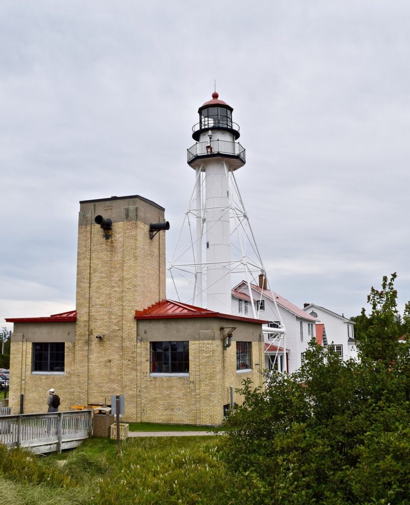
Eleven miles north of Paradise, Whitefish Point sticks out into Lake Superior at the entrance to Whitefish Bay, on the stretch of coast sailors call the Graveyard of the Great Lakes. The Great Lakes Shipwreck Museum here tells the story of the wrecks, and its centerpiece is the original bell of the Edmund Fitzgerald, the ore carrier that sank in a November 1975 storm about 17 miles from the point with all 29 crew; the bell was recovered in 1995 and hangs as a memorial. The museum is open daily from May 1 to October 31, 9 a.m. to 5 p.m.; admission is $13 for adults, $9 for children 17 and under, free under 5, or $40 for a family with two adults and two or more children, and it includes the lightkeeper’s quarters, the surfboat house and the motor lifeboat house. The lighthouse, first lit in 1849, is the oldest active light on Lake Superior.
The point is also one of the best bird-watching spots in the Midwest, especially for hawks, owls and waterbirds on spring migration, and part of it is a national wildlife refuge, so collecting rocks or anything else is prohibited. The beach is rocky and the lake cold and rough: watch the freighters go by, but don’t swim.
For a wilder side trip, the Crisp Point Lighthouse stands alone on the Lake Superior shore west of Whitefish Point, reached by long gravel and sand roads; allow plenty of time, fill the tank first and don’t try it in a low car after heavy rain.
Point Iroquois and the road to the Soo
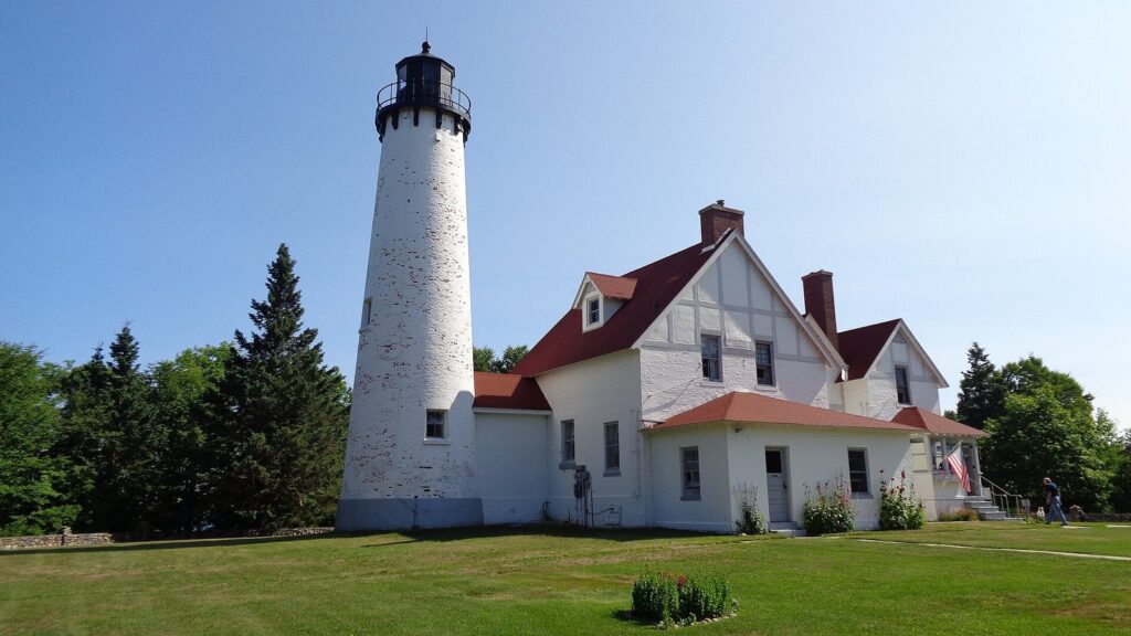
From Paradise, the prettiest route to Sault Ste. Marie follows the shore of Whitefish Bay east, past beaches and the 19th-century Point Iroquois Light Station, before turning inland to the Soo. The drive takes a little over an hour.
Sault Ste. Marie and the Soo Locks
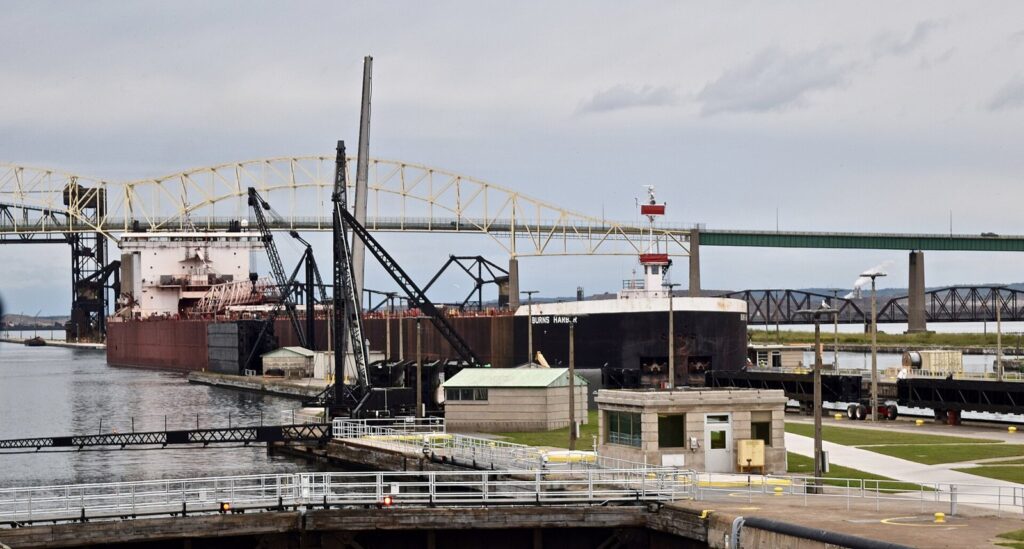
Sault Ste. Marie, founded in 1668 and the oldest city in Michigan, sits on the St. Marys River where Lake Superior drops about 21 feet toward Lake Huron, and the Soo Locks lift and lower the freighters that carry iron ore and grain through the Great Lakes. Soo Locks Park, run by the US Army Corps of Engineers, and its elevated viewing platform are open daily all year, and the visitor center is open May 1 to October 31 from 10 a.m. to 7 p.m. Watching a 1,000-foot freighter rise or drop just across the lock wall is free and oddly mesmerizing; the visitor center posts which ships are coming. To go through the locks yourself, two companies run boat tours; in 2026 Original Soo Locks Boat Tours charged $30 for adults and $10 for ages 5 to 17, and Famous Soo Locks Boat Tours started at about $32. A new Poe-sized lock is under construction, due to be finished around 2030.
Downtown’s Portage Avenue runs along the locks, with restaurants and shops a short walk from the viewing platform, so it’s easy to eat while you wait for a ship. The International Bridge crosses to Sault Ste. Marie, Ontario; you’ll need a passport or other accepted document to cross and come back.
St. Ignace and the Mackinac side
St. Ignace, at the north end of the Mackinac Bridge, is where most visitors from the south start the loop. It has motels, the Arnold Transit and Shepler’s ferry docks for Mackinac Island (2026 adult round trips were $37 and $39), Castle Rock, a limestone stack with a lookout, and the Museum of Ojibwa Culture, open seasonally. If you’re staying in the Straits area, the falls make a long day trip, about an hour and a half each way.
Newberry and Muskallonge Lake
Newberry, the Luce County seat about 30 minutes southwest of the Upper Falls, calls itself the moose capital of Michigan and is the practical base if you’re coming from Munising and Pictured Rocks. It has gas, groceries, motels and restaurants. North of town, on the Lake Superior shore between the lake and Muskallonge Lake, Muskallonge Lake State Park has a rustic beach where people hunt for agates.
Drummond Island and the Les Cheneaux Islands
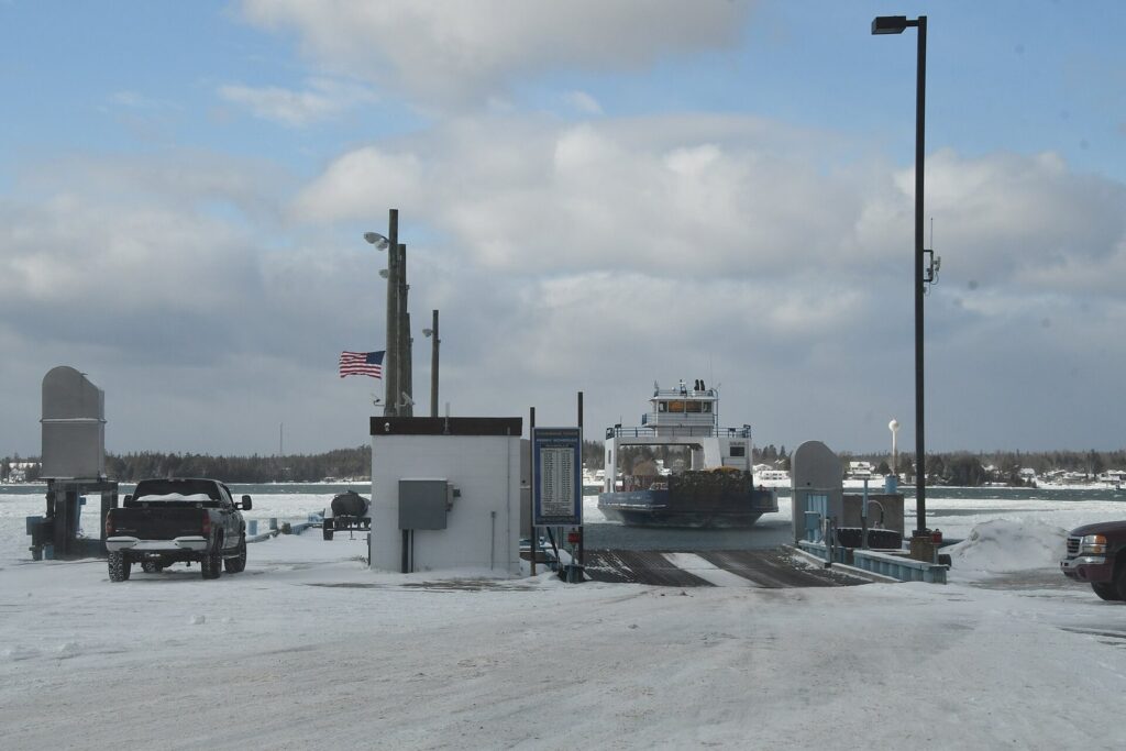
At the far eastern tip of the U.P., about 1 hour 10 minutes from the Soo, a car ferry run by the Eastern Upper Peninsula Transportation Authority crosses from DeTour Village to Drummond Island in about 10 minutes, hourly, every day of the year; in 2026 a round trip was $20 per car and $2 on foot, with cashless payment preferred. The island is big, wooded and quiet, with rocky shores, ORV and snowmobile trails and fishing.
On the way back toward St. Ignace, the Les Cheneaux Islands, a cluster of 36 islands and channels off Hessel and Cedarville along the Lake Huron shore, are a paddler’s and boater’s corner of Michigan known for their antique wooden boats, which star in a boat show there each August. Hessel is about 30 minutes from St. Ignace.
A two- or three-day loop
Day 1: Cross the Mackinac Bridge and drive about 1 hour 30 minutes to the Upper Falls. Walk the boardwalk and the gorge platform, have lunch at the brewery, then drive 13 minutes to the Lower Falls and row or walk to the island. Stay in Paradise or at the Lower Falls campground.
Day 2: Morning at Whitefish Point and the Shipwreck Museum, then the shore road past Point Iroquois to Sault Ste. Marie for the Soo Locks viewing platform and a boat tour. Stay in the Soo.
Day 3 (optional): Drive to DeTour Village for the Drummond Island ferry, or head back toward St. Ignace through the Les Cheneaux Islands, with time for Mackinac Island if you’re staying on.
How to get to Tahquamenon Falls
Almost everyone drives. From the Lower Peninsula, take I-75 across the Mackinac Bridge ($4.00 toll per car in 2026) to St. Ignace, then follow the signs north to Paradise and west on M-123 to the falls; from Munising and the west, come in through Newberry. From Chicago, allow about eight hours.
| From | To the Upper Falls | To Paradise |
|---|---|---|
| Detroit | About 5 h 45 (372 mi) | About 5 h 25 (358 mi) |
| Grand Rapids | About 5 h 10 (319 mi) | About 4 h 50 (305 mi) |
| Chicago | About 8 h (498 mi) | About 7 h 40 (483 mi) |
| Mackinaw City | About 1 h 35 (83 mi) | – |
| St. Ignace | About 1 h 30 (77 mi) | About 1 h 10 (63 mi) |
| Sault Ste. Marie | About 1 h 25 (76 mi) | About 1 h 10 (62 mi) |
| Munising (Pictured Rocks) | About 1 h 35 (85 mi) | – |
| Marquette | About 2 h 25 (128 mi) | – |
Times are free-flow driving times; add time for summer bridge traffic and for deer on M-123 at dawn and dusk. The nearest airport with scheduled flights is Chippewa County International, south of Sault Ste. Marie. The whole area is on Eastern time.
Planning checklist
- Recreation Passport on the car: buy it with your Michigan plate renewal, or online or at the park if you’re a non-resident.
- Shuttle: book the Hunter Shuttle ahead in summer if you plan to hike the River Trail one way.
- Fuel and food: fill up in Paradise, Newberry or the Soo; services in the park are limited to the pub and the cafe.
- Bugs and weather: repellent and a head net from late May to early July, layers year-round, cleats in winter.
- Maps: download them before you go; coverage is patchy.
- Air quality and closures: check the DNR park page before you leave. In July 2026, the state’s websites carried air-quality alerts for wildfire smoke, and trail or campground closures after storms are posted on the park page too.
- Reservations: campsites, backcountry sites and the park lodge book through MIDNRReservations.com; summer weekends and fall-color weekends go first.
Safety
- Stay behind the railings at the Upper Falls and off the wet rock at the Lower Falls. The current near the drops is stronger than it looks.
- Black bears live in the park. Keep a clean campsite, store food in your vehicle or a hard-sided container, and never feed wildlife.
- Bugs peak from late May through early July: black flies, mosquitoes and deer flies. Carry repellent and a head net for the River Trail.
- Moose and deer cross M-123 at dawn and dusk; slow down between Paradise and the falls.
- Lake Superior at the Rivermouth and Whitefish Point is cold enough to cause cold shock even in summer, and waves build quickly.
- Winter ice makes the paths and platforms slippery; wear traction cleats and stay back from ice shelves at the falls.
- Cell coverage can be patchy in the park and along the shore roads. Download maps before you arrive.
Is Tahquamenon Falls worth visiting?
Yes. The Upper Falls is one of the largest waterfalls in the eastern United States, it’s easy to see (now with an accessible route to the brink), and the Lower Falls island, the River Trail and the eastern U.P. loop turn it into a full trip.
Make it more than a stop by adding Whitefish Point and the Soo Locks, or pairing it with Pictured Rocks, about 1 hour 35 minutes west.
Best for families, photographers, anyone who can’t manage long hikes (the boardwalk reaches the brink), and road-trippers building an eastern U.P. loop.
It’s less worth it as a rushed day trip from the Lower Peninsula in peak summer: three hours of driving each way from the bridge area for an hour at a crowded platform. Stay at least one night nearby.
What to skip, and what to do instead
Skip the Toonerville Trolley. It has closed after its 96th season, although many older roundups still list it. Hike the River Trail or take the Hunter Shuttle between the falls instead.
Skip midday at the Upper Falls in August. Go before 10 a.m. or after 5 p.m.
Skip wading near the drops at the Lower Falls. The rock is slick and the current strong; stay in the calm shallows around the island.
Skip swimming at Whitefish Point. Lake Superior there is cold and rough; the beaches around Paradise and the Rivermouth are calmer.
Skip only one falls. They’re 13 minutes apart by car, and the Lower Falls island is the part many people like best.
Frequently asked questions
Which is better, Upper or Lower Tahquamenon Falls?
The Upper Falls is more impressive: a single drop of about 48 feet and more than 200 feet wide, with an accessible boardwalk to the brink. The Lower Falls is smaller but more fun, a set of cascades around an island you can reach by footbridge or rowboat. They’re 4 miles apart on the River Trail or about 13 minutes by car, so see both if you can.
How much does it cost to get into Tahquamenon Falls?
There’s no separate admission; you need a Michigan Recreation Passport on your vehicle. Michigan residents pay $15 a year with their plate renewal. Non-residents pay $12 for a day or $42 for an annual pass in 2026, which also covers every other Michigan state park. The Hunter Shuttle, rowboat rentals and campsites cost extra, and non-campers pay $10 to use the park’s sanitation stations.
How long is the hike between the Upper and Lower Falls?
The River Trail between the falls is about 4 miles one way, or 8 miles round trip, on a primitive, moderately difficult path through old-growth forest along the river. Most hikers take two to three hours each way. In summer, the fee-based Hunter Shuttle runs between the falls from noon to 8 p.m., so you can hike one way and ride back.
Why is Tahquamenon Falls brown?
The brown, root-beer color comes from tannins leached from the cedar, spruce and hemlock swamps the river drains, the same compounds that color tea. The water isn’t polluted. Its softness also makes it foam as it churns below the falls, producing the cream-colored froth that people sometimes mistake for soap suds. Rivers across the eastern U.P.’s swamp country share the same tea color.
Is Tahquamenon Falls open in winter?
Yes, the park is open all year. In winter, ice forms around the Upper Falls, and the park grooms about 4 miles of cross-country ski trails near the Upper Falls and marks 9 miles of snowshoe trails. Snowmobile Trail 45 reaches both falls, the Hemlock campground loop stays open for winter camping, and the park lodge rents year-round. Paths can be icy, so wear traction.
How many steps are at Tahquamenon Falls?
The old stairway to the brink of the Upper Falls had 94 steps; in 2026 it was replaced by a 1,100-foot accessible boardwalk with switchbacks, so you can now reach the brink without stairs. The separate stairway down to the gorge viewing platform has 116 steps. The Lower Falls has a short walk to its platform and a half-mile accessible boardwalk.
Are dogs allowed at Tahquamenon Falls?
Yes. Leashed dogs are allowed on all of the park’s trails, including the viewing platforms at both falls, on a leash no longer than 6 feet and under your control. Clean up after them, keep them off the groomed ski trails in winter, and remember that black bears and other wildlife live in the park. Dogs are also welcome in the campgrounds on a leash.
Where should I stay near Tahquamenon Falls?
Paradise, about 20 minutes from the Upper Falls, is the closest town and handy for Whitefish Point. Newberry, 30 minutes away, has more services, and Sault Ste. Marie, about an hour and a half away, has the most hotels plus the Soo Locks. Inside the park, choose the Lower Falls or Rivermouth campgrounds or the eight-person park lodge.
Sources and verification
Everything on this page was checked on September 23, 2026 against the organizations listed here. This guide is compiled from those sources; it doesn’t claim first-hand visits.
- Michigan DNR: Tahquamenon Falls State Park, covering the boardwalk, trails, campgrounds, lodge, shuttle, rowboats, winter trails and pet rules
- Great Lakes Shipwreck Museum: admission, hours and location
- Soo Locks Visitors Center Association, plus the Sault Ste. Marie CVB and the boat tour operators
- Eastern Upper Peninsula Transportation Authority: ferry system
- UP Travel: Tahquamenon Falls State Park, plus its fall color report
Also checked: the DNR’s Recreation Passport page and its 2024 notice on the Upper Falls stairway project; reporting on the new boardwalk’s opening in 2026; the Mackinac Bridge Authority’s fare schedule; the Toonerville Trolley’s closure; and drive times from a routing service.
Michigan Tourism Guide is an independent publication. It is not affiliated with Pure Michigan or any agency or business named here.
Photo credits
- Upper Tahquamenon Falls (featured image): photo by Joe Passe, Wikimedia Commons (CC BY-SA 2.0)
- Upper Falls from the brink side: photo by Joe Passe, Wikimedia Commons (CC BY-SA 2.0)
- Lower Falls: photo by Joe Passe, Wikimedia Commons (CC BY-SA 2.0)
- River Trail sign: photo by Tony Webster from Minneapolis, Minnesota, United States, Wikimedia Commons (CC BY-SA 2.0)
- Tahquamenon River below the Lower Falls: photo by Notorious4life (talk) (Uploads), Wikimedia Commons (CC0)
- Whitefish Point Light: photo by Deb Nystrom from Ann Arbor, Michigan, USA, Wikimedia Commons (CC BY 2.0)
- Point Iroquois Light: photo by Notorious4life (talk) (Uploads), Wikimedia Commons (CC0)
- Freighter entering the Poe Lock, Soo Locks: photo by Deb Nystrom from Ann Arbor, Michigan, USA, Wikimedia Commons (CC BY 2.0)
- Drummond Islander IV ferry: photo by Corvair Owner, Wikimedia Commons (CC BY-SA 2.0)