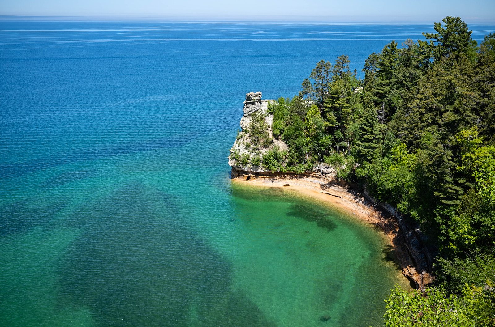
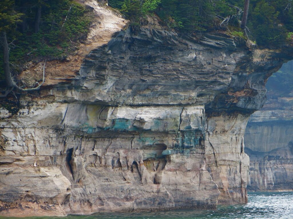
The colors that give the cliffs their name come from groundwater. It seeps through cracks in the sandstone and leaves stripes of whatever it carries down the rock face: iron for the reds and oranges, copper for the blues and greens, manganese for the browns and blacks, limonite for the white. Pictured Rocks National Lakeshore puts about 15 miles of those painted cliffs, up to about 200 feet high, along a 42.8-mile stretch of Lake Superior shoreline in the Upper Peninsula, between Munising and Grand Marais. Most of the best of it faces the water, and that shapes every decision about how to visit.
The short answer: the best way to see Pictured Rocks is from the water first, on a boat cruise from Munising (or a guided kayak tour if you’re fit and the lake is calm), then from land at Miners Castle and on the Chapel Loop hike. One full day covers the highlights; two or three days let you see the whole lakeshore from Munising to Grand Marais. Entry costs $25 per private vehicle for seven days (2026), and cruises frequently sell out in summer, so book ahead.
The details below were checked September 23, 2026 against the operators’ and agencies’ own websites, including 2026 cruise schedules and National Park Service fees and camping rules.
On this page: At a glance · Is it worth it? · Boat vs. kayak vs. hike · The cruises · Kayaking · Hiking · Stops from west to east · When to go · How many days · Munising, Grand Marais and Grand Island · Where to stay and camping · Fees and reservations · Getting there · Pictured Rocks vs. the Apostle Islands · A short history · Safety · What to skip · FAQ
Pictured Rocks at a glance
| What you need to know | Details (checked September 23, 2026) |
|---|---|
| What it is | America’s first national lakeshore, established in 1966: 73,235 acres along 42.8 miles of Lake Superior, with cliffs about 200 feet high, beaches, dunes, waterfalls and about 111 miles of trail |
| Where | Alger County in the central Upper Peninsula, between Munising (west end) and Grand Marais (east end), on Eastern time |
| Visitors | 933,966 recreation visits in 2025; about 62% come in June, July and August and 23% in September and October |
| Entry fee (2026) | $25 per private vehicle for 7 days; $20 per motorcycle; $15 per person on foot or bike; $45 annual pass; federal America the Beautiful passes accepted |
| Boat cruises (2026) | Pictured Rocks Cruises from Munising: Classic Cruise $48 adult, 2 h 40 min (May to September 6); Spray Falls Cruise $56 adult, 2 h (May to October 18); ages 4-12 $19 |
| Camping (2026) | 3 drive-in campgrounds, $25 a night, May 15 to October 15; 13 backcountry camping areas by permit year-round |
| Drive to Munising | About 6 h 25 min from Detroit and from Chicago; 5 h 45 min from Grand Rapids |
| Time needed | 1 day for the highlights; 2 to 3 days for the whole lakeshore |
| Best time | Late June to August for boats and swimming weather; the first half of October for fall color; winter for frozen waterfalls |
Is Pictured Rocks National Lakeshore worth visiting?
Yes, and it rewards the effort it takes to get there. Few places in the Midwest combine this much scenery in one stretch: 200-foot cliffs streaked with color, sea arches and caves, clear green water, beaches that run for miles, a lighthouse, waterfalls that pour straight into Lake Superior and a wall of sand dunes at the east end. It’s also far from everywhere. Munising is about six and a half hours from both Detroit and Chicago, so this is a trip to plan, not a detour.
For first-timers: yes. A cruise, Miners Castle and a short waterfall walk make an easy, memorable day, even with small children.
For hikers: absolutely. The Chapel Loop is one of the best day hikes in Michigan, and the Lakeshore Trail runs the length of the park.
For paddlers: yes, with a guide. Paddling beneath the cliffs is the closest look you can get, but Lake Superior punishes mistakes.
For photographers: yes. Clear water, colored stone and fall hardwoods make this one of the most photogenic places in the state.
Less worth it: a rushed day trip from far away in bad weather, when boats cancel and fog hides the cliffs; or a visit between late October and December, after the boats stop and before the winter ice.
Boat, kayak or hike: the best way to see Pictured Rocks
The cliffs face Lake Superior, and much of the painted stone is visible only from the water. That’s why most visitors take a boat, many paddle, and the best trips add a hike or two for the views from above. Here’s how the options compare.
| Boat cruise | Guided kayak tour | Hiking and overlooks | |
|---|---|---|---|
| Cost | $48 or $56 per adult, $19 for ages 4-12 (2026), plus parking in Munising | Priced per person by operator and tour length; the most expensive option | Only the park entry fee: $25 per vehicle for 7 days (2026) |
| Time | 2 hours (Spray Falls) or 2 hours 40 minutes (Classic), plus 30-45 minutes to check in | About 3 hours to a full day | From a 10-minute walk to Miners Castle to a full day on the Chapel Loop or longer |
| What you see | The long run of cliffs from the water, with narration | The cliffs, caves and arches up close, at water level | The views from above, beaches, waterfalls, Chapel Rock, the lighthouse and dunes |
| Who it suits | Everyone, including young children and anyone with limited mobility | Fit adults and older kids who are comfortable in a boat in cold water | Anyone who can walk; the big hikes suit fit walkers |
| Weather risk | Moderate: rough water can shorten or cancel cruises, with partial refunds | High: tours cancel when wind and waves build | Low: rain and fog spoil views but rarely stop a hike |
The honest verdict: if you only do one thing, take the cruise. If you can do two, add the Chapel Loop or at least Miners Castle and Miners Falls. Kayaking is the most memorable way to see the cliffs and the one most likely to be canceled, so book it early in your stay and keep the cruise as a fallback.
Pictured Rocks Cruises: which cruise, and how to book
Pictured Rocks Cruises, the lakeshore’s boat-tour operator, sails from its dock at 100 City Park Drive in downtown Munising. Its 2026 lineup has four options:
| Cruise | Length | Adult fare (2026) | Season |
|---|---|---|---|
| Classic Cruise | 2 h 40 min | $48 | May to September 6 |
| Sunset Classic Cruise | 2 h 40 min | $48 | Mid-June to September 6 |
| Spray Falls Cruise | 2 h | $56 | May to October 18 |
| Sunset Spray Falls Cruise | 2 h | $56 | June to October, evening departures |
Children ages 4 to 12 pay $19 on any cruise, and the youngest children pay $1. The operator says cruises frequently sell out and recommends buying tickets in advance, and asks passengers to arrive 30 to 45 minutes before departure. If weather stops a cruise from completing its route, you get a partial refund based on how much of the trip you completed. Check the operator’s site for each cruise’s route and turnaround point before you choose.
What you’ll see from the water
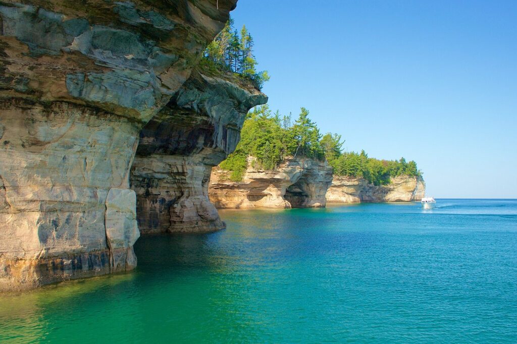
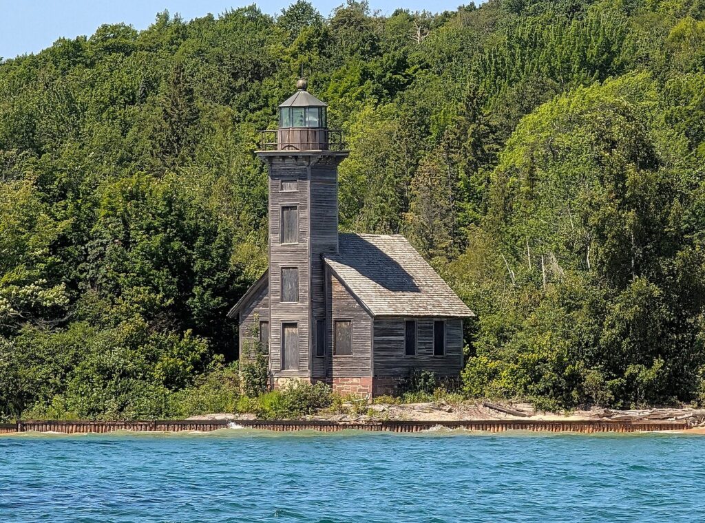
Boats leave Munising Bay past Grand Island and its weathered East Channel Lighthouse, then turn northeast along the cliffs. The first big landmark is Miners Castle, the turreted formation you can also see from the overlook above. From there the cliffs rise and fall for miles, with named features along the way such as Lovers Leap, Grand Portal Point, Indian Head and Battleship Row, and with caves and arches cut into the base of the rock. Near the eastern end of the cliffs, Chapel Rock stands alone on its pedestal and Spray Falls pours straight off the cliff edge into Lake Superior. What you see depends on the cruise you choose and on the lake that day, so check the operator’s description of each route.
Photography tips
The painted cliffs look their most colorful in warm, low light, which is what the sunset cruises are timed for, and the water looks its clearest green on calm, sunny days around midday. A polarizing filter cuts the glare on the water and deepens the colors in the rock. One rule to know: launching drones is prohibited in national park units, Pictured Rocks included, so leave the drone at home.
Tips for the cruise
- Book early in your trip. If a cruise is canceled for weather, you’ll have another day to try.
- Morning or evening? Sunset cruises light the cliffs in warm evening color; midday cruises show the clearest green water. Either beats a gray afternoon.
- Bring layers. Even in August, the wind on Lake Superior feels cold, especially on the upper deck.
- In the fall, note the change. The Classic Cruise ends September 6, so September and October visitors book the Spray Falls Cruise, which runs through October 18 in 2026.
Other boats
Munising also has glass-bottom boat tours over the shipwrecks in and around Munising Bay, part of an underwater preserve, which run in the summer season; check dates and prices with the operator. And a passenger ferry crosses to Grand Island, just offshore, from late spring to early fall (see the Grand Island section below).
Kayaking Pictured Rocks
Paddling under the cliffs is the most intimate way to see Pictured Rocks: you can look up into the caves, run your eyes along the mineral stripes and float in water clear enough to see the rocks far below. It’s also the riskiest. Lake Superior is cold enough to cause cold shock even in August, the wind can rise in minutes, and along much of the cliff line there’s nowhere to land.
For most visitors, the right answer is a guided tour. Several outfitters run guided trips from the Munising area, including Pictured Rocks Kayaking and Yooper Yachts, which both list 2026 tours, and the National Park Service keeps a list of authorized kayak tour operators. Tours range from about three hours to a full day and are priced per person; compare what’s included, such as transport to the launch, a guide-to-paddler ratio, dry bags, wetsuits and whether a support boat follows the group.
Only experienced sea kayakers with cold-water gear should paddle the cliffs on their own, and even they should check the marine forecast and turn back early if the wind picks up. The inland lakes and the sheltered water near Sand Point and Munising Bay are gentler places for beginners to paddle independently.
Hiking Pictured Rocks
With about 111 miles of trail, Pictured Rocks has hikes for every energy level, and several of its best views are only reachable on foot.
- Miners Castle overlook: short, paved and accessible, with views down to the rock formation and the turquoise water around it. Miners Castle lost one of its two turrets to erosion in 2006.
- Miners Falls: a short, easy woodland walk to a waterfall near Miners Castle, good for families.
- Munising Falls: a short, paved path from the visitor center to a waterfall in a sandstone amphitheater, the easiest walk in the park.
- The Chapel Loop: the classic, about 10 miles round trip, taking in Chapel Falls, Chapel Rock, Mosquito Beach and several miles of clifftop trail. Allow most of a day.
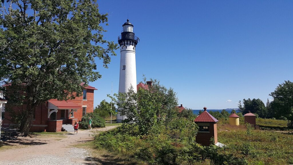
- Au Sable Light Station: a flat walk along the shore of about 1.6 miles each way from the Hurricane River area to the 1874 lighthouse.
- Log Slide overlook: a short walk to a viewpoint high above Lake Superior, with the Grand Sable Dunes stretching east.
- The Lakeshore Trail: the North Country Trail’s route through the park, running the length of the lakeshore for backpackers.
The Chapel Loop, step by step
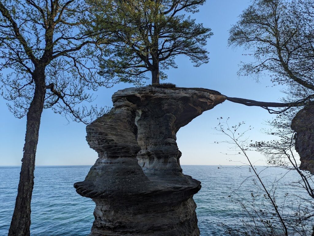
The Chapel Loop is the hike most people mean when they talk about hiking Pictured Rocks, and it’s worth a full day. From the Chapel trailhead at the end of Chapel Road, one branch heads through the woods past Chapel Falls to Chapel Rock, about 3 miles out, where the trail meets the lake. From there the Lakeshore Trail follows the clifftops west for several miles, with repeated views down the cliffs to the water, before dropping to Mosquito Beach. The other branch climbs back from Mosquito Beach, past Mosquito Falls, to the trailhead, closing a loop of about 10 miles. Which way to walk is personal preference; many hikers do Chapel Falls and Chapel Rock first while their legs are fresh and save the beach for a late-afternoon rest. Carry more water than you think you need, start early in summer to find parking, and allow six hours or more with stops.
Backpacking the Lakeshore Trail
The Lakeshore Trail, the North Country Trail’s route through the park, runs the length of the lakeshore between Munising and Grand Marais, and a multi-day walk along it is one of the classic backpacking trips in the Midwest. Camping is allowed only in the 13 designated backcountry areas, with a reservation and permit ($15 per trip plus $5 per person per night in 2026). Because the trail is point to point, plan your transport at both ends before you start: leave a car at each end, or arrange a shuttle. Bear-proof food storage and good rain gear are essential, and the stretches along the cliff tops are exposed to wind and weather.
Waterfalls in and around the park
Waterfalls are one of the lakeshore’s quieter pleasures. Inside the park, Munising Falls, Miners Falls, Mosher Falls and Chapel Falls are all reachable on foot, and Sable Falls tumbles down to the lake near Grand Marais. Spray Falls and, in spring, Bridalveil Falls pour over the cliffs themselves and are best seen from a boat. Munising has several more just outside the park boundary, including Wagner Falls and Alger Falls. The falls run fullest in spring and after heavy rain, and several shrink to a trickle by late summer.
The stops from west to east: Munising to Grand Marais
The lakeshore is a long, thin park, and the easiest way to plan it is from west to east along the main road, County Road H-58, which runs behind the park between Munising and Grand Marais, a drive of a bit over an hour without stops. Side roads lead north from it to the lake.
- Munising Falls: at the east edge of Munising, the Munising Falls Visitor Center and a short paved path to the falls.
- Sand Point: a beach and a marsh boardwalk on Munising Bay, beside the park headquarters in a former Coast Guard station. A calm spot for young kids and beginning paddlers.
- Miners Castle, Miners Falls and Miners Beach: reached by Miners Castle Road off H-58. The overlook is the park’s most visited spot, and Miners Beach is a good place to watch the waves.
- The Chapel area: down Chapel Road, a gravel road, for Chapel Falls, Chapel Rock, Mosquito Beach and the start of the Chapel Loop. Arrive early on summer weekends, when the trailhead parking fills.
- Twelvemile Beach: a long, quiet stretch of sand and pebbles with a campground above it. The cliffs give way to beach here.
- Hurricane River and Au Sable Light Station: a campground at the river mouth and the shoreline walk to the lighthouse, with old shipwreck timbers sometimes visible on the beach along the way.
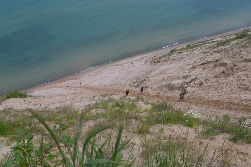
- The Log Slide: where loggers once sent timber down the dune to the lake. The overlook is short and dramatic; the climb down is the park’s most regretted decision (see the safety section).
- Grand Sable Visitor Center, Sable Falls and the Grand Sable Dunes: just west of Grand Marais, with a stairway down past Sable Falls to the beach and dunes perched high above the lake.
- Grand Marais: the small harbor town at the east end, with a maritime museum in season.
When to go to Pictured Rocks
| Season | What it’s like | Crowds | Watch for |
|---|---|---|---|
| May and early June | Waterfalls at their fullest, cruises starting up, fresh green woods; cold water and cool days | Light to moderate | Black flies and mosquitoes arrive by June |
| Late June to August | Every cruise running, the warmest weather, long evenings for sunset cruises | Heavy: about 62% of the year’s visits | Booked-out cruises, full trailhead lots, the most traffic on H-58 |
| September to mid-October | Crisp days, fewer people, fall color usually peaking in the first half of October | Moderate: about 23% of visits | The Classic Cruise ends September 6; campgrounds close October 15; the last cruise is October 18 (2026) |
| Late October to December | Bare trees, gray skies and November storms on Lake Superior | Very light | No boats; many seasonal businesses closed |
| January to March | Frozen waterfalls, ice formations along the shore, snowshoeing and cross-country skiing | Light, busier on ice-climbing weekends | Unplowed park roads, deep snow and dangerous ice |
Summer
Summer is when Pictured Rocks is easiest to enjoy and hardest to have to yourself. Everything is running, the water is at its clearest green and the days are long, but the cruises sell out, Miners Castle and the Chapel trailhead fill by late morning and rooms in Munising book up. The trick is simple: take the first cruise of the day or a sunset cruise, hit the trailheads early, and stay midweek if you can.
Fall color
Fall is the season the lakeshore’s regulars love. The hardwoods along the top of the cliffs turn in the first half of October in most years, and UP Travel’s 2026 outlook put the central U.P. peak in the first and second weeks of October. That timing has two catches: the Classic Cruise has already ended by then, and the Spray Falls Cruise stops on October 18, so book the boat for the first half of the month.
Where to watch the sunset
Lake Superior sunsets are a reason to stay near the water at the end of the day. Sand Point and Miners Beach are easy evening stops close to Munising, Twelvemile Beach is a quieter choice midway along H-58, and at the east end the beach below the Grand Sable Dunes and the harbor in Grand Marais both work well. The sunset cruises, which leave in the early evening, put you on the water for the best of the light.
Winter and the ice
Winter turns Pictured Rocks into a different park. Munising Falls and the smaller falls around town freeze into columns of blue-white ice, the cliffs along the shore grow ice curtains, and the area draws ice climbers each February. The park’s ski trails near Munising and Grand Marais are groomed in season, and snowshoeing is excellent. Most park roads aren’t plowed, so plan on short walks from plowed roads or on skis and snowshoes. Snowmobilers use designated unplowed routes, and the 2026 snowmobile entry fee is $15. Dress for real cold, carry traction devices for icy trails, and tell someone where you’re going, because winter daylight is short and cell coverage is patchy.
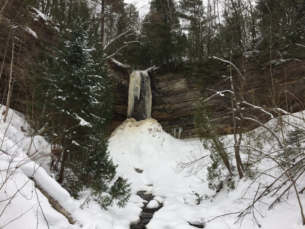
The ice caves along Grand Island’s eastern shore draw crowds in the rare winters when Munising Bay freezes solid. Never walk out on the bay unless local authorities have confirmed that the ice is safe. Lake Superior ice shifts with wind and current, can look solid while it’s thin, and breaks without warning. If you’re not sure, stay on shore; the frozen waterfalls on land are spectacular enough.
How many days do you need at Pictured Rocks?
One day covers the highlights; two or three let you see the whole lakeshore without rushing; four let you add Grand Island and a long hike. Here’s how to split them.
One day
- Morning: the first cruise from Munising.
- Midday: Munising Falls, then lunch in town.
- Afternoon: Miners Castle, Miners Falls and Miners Beach.
- Evening: Sand Point for a sunset walk, or a sunset cruise if you didn’t take the morning boat.
Two days
- Day 1: as above.
- Day 2: the Chapel Loop, starting early, with a swim at Mosquito Beach if you’re brave; or a guided kayak tour in the morning and the Chapel area in the afternoon.
Three days
- Days 1 and 2: as above.
- Day 3: drive H-58 east to Twelvemile Beach, walk to Au Sable Light Station, stop at the Log Slide overlook, and finish at the Grand Sable Dunes, Sable Falls and Grand Marais. Stay the night in Grand Marais or drive back.
Four days
- Add: a day on Grand Island by ferry and bike, or an overnight backpacking trip on the Lakeshore Trail with a backcountry permit.
Gateway towns: Munising, Grand Marais and Grand Island
Munising
Munising, at the west end, is the lakeshore’s main gateway and the largest town near it. The cruises leave from its downtown waterfront, the Munising Falls Visitor Center is on the east edge of town, and it has most of the area’s motels, hotels, cabins, restaurants and outfitters. Several waterfalls are within a few minutes’ drive. It’s the base for anyone doing the cruises and the western half of the park.
Grand Marais
Grand Marais, at the east end, is a small harbor town with a handful of inns, cabins and restaurants, the Grand Sable Visitor Center just west of town and the Grand Sable Dunes on its doorstep. It’s quieter than Munising and a good base for the eastern half of the park: the dunes, the Log Slide, Au Sable Light Station and Twelvemile Beach. Book early; there isn’t much lodging.
Grand Marais also has its own approach. M-77 runs straight north to town from M-28 at Seney, so drivers coming from the Mackinac Bridge can start at the east end, work west along H-58 and finish in Munising for a cruise, instead of backtracking. In town, the harbor and its breakwall make an easy evening walk, the park service runs a small maritime museum in summer, and the beach along the bay is one of the calmer places on this stretch of Lake Superior to dip a toe in.
Grand Island
Grand Island sits just off Munising in Lake Superior and is managed by the U.S. Forest Service as a national recreation area. It’s big and lightly developed, with sandy beaches, cliffs of its own, an old lighthouse on its east channel and trails that make a long day on a mountain bike. A passenger ferry runs from a landing just west of Munising from late spring into early fall, and bikes can be brought over or rented on the island; check the ferry’s current schedule and fares before you go, and carry water and food, because there are no services to speak of once you land.
Marquette as an alternative base
If you want a bigger town with more restaurants and lodging, Marquette, the Upper Peninsula’s largest city, is about an hour west of Munising. It works for a day trip to the western end of the lakeshore, but you’ll spend a lot of the day driving if you want to see the eastern end too.
Where to stay near Pictured Rocks, including camping
Munising has the most choice: chain and independent motels, a few larger hotels, cabins and vacation rentals. Grand Marais has a smaller set of inns and cabins. Both fill on summer weekends and fall color weekends, so book as soon as your dates are fixed, especially for July, August and the first half of October. Prices climb with demand in those months and fall sharply after mid-October.
Camping inside the park
All camping at Pictured Rocks is by reservation in designated sites. The park has three drive-in campgrounds, all rustic: Little Beaver Lake (8 sites), Twelvemile Beach (36 sites) and Hurricane River (21 sites). Each costs $25 a night, they’re open May 15 to October 15, and reservations open on Recreation.gov up to six months in advance; summer weekends go quickly.
Backpackers can use 13 backcountry camping areas along the Lakeshore Trail, year-round, with a reservation and permit: $15 per trip plus $5 per person per night. Black bears live here, and the park requires all food, drinks, cooking gear and pet food to be sealed in a hard-sided vehicle when not in use, or in the park’s metal food-storage boxes if you don’t have one.
If the park’s campgrounds are full, the surrounding Hiawatha National Forest and state forest land have more campgrounds within a short drive.
Fees, passes and reservations
How much does it cost to get into Pictured Rocks?
| Pass (2026) | Price | Good for |
|---|---|---|
| Private vehicle | $25 | 7 days |
| Motorcycle | $20 | 7 days |
| Per person (walking or biking in) | $15 | 7 days |
| Snowmobile | $15 | 7 days |
| Pictured Rocks annual pass | $45 | 12 months, this park only |
| America the Beautiful annual pass | $80 for U.S. residents, $250 for non-residents | All federal fee areas for a year |
The park pass is separate from the cost of a cruise or kayak tour, which leave from Munising and are paid to the operator. If you’ll also visit Sleeping Bear Dunes or other federal sites in the same year, the America the Beautiful pass can pay for itself.
What a Pictured Rocks trip costs
| Item | Price (2026) | Notes |
|---|---|---|
| Park entry, one car | $25 | Covers everyone in the vehicle for 7 days |
| Classic Cruise, family of four (2 adults, 2 kids 4-12) | $134 | $48 per adult, $19 per child; May to September 6 |
| Spray Falls Cruise, family of four | $150 | $56 per adult, $19 per child; through October 18 |
| Drive-in campsite | $25 a night | May 15 to October 15, reserved on Recreation.gov |
| Backcountry camping, two people, two nights | $35 | $15 reservation fee plus $5 per person per night |
| Guided kayak tour | Priced per person by operator | The biggest single cost for most families; check what’s included |
| Overlooks, beaches, waterfalls and trails | Included with park entry | No extra charge for Miners Castle, the Chapel Loop or the lighthouse walk |
Lodging is the other big variable. Munising and Grand Marais rooms cost the most on July and August weekends and fall color weekends, and far less from mid-October through spring, outside winter festival weekends.
Do you need a reservation for Pictured Rocks?
Not to enter the park: there’s no timed-entry system, and you can drive in whenever you like. You do need reservations for all camping, including backcountry sites, and in practice you should book cruises and kayak tours ahead in summer and on fall color weekends, when they sell out.
Getting to Pictured Rocks
| From | Distance to Munising | Typical drive |
|---|---|---|
| Grand Rapids | 352 miles | about 5 h 45 min |
| Detroit | 413 miles | about 6 h 25 min |
| Chicago | 381 miles | about 6 h 25 min |
| Cleveland | 564 miles | about 8 h 45 min |
| Columbus, Ohio | 586 miles | about 9 h 15 min |
| Toronto | 595 miles | about 9 h 25 min |
| Indianapolis | 607 miles | about 9 h 30 min |
These are free-flowing times; summer weekend traffic at the Mackinac Bridge and road work on two-lane U.P. highways can add to them. Drivers from Michigan’s Lower Peninsula cross the Mackinac Bridge; Chicago drivers usually come up through Wisconsin and lose an hour, because Munising is on Eastern time. The nearest airport with airline service is Sawyer International (SAW) near Marquette, and you’ll need a car from there. Fill the tank in Munising or Grand Marais before driving H-58; services are few along the way, and cell coverage is patchy.
Food, fuel and supplies
There are no restaurants or stores inside the park, so plan meals around Munising and Grand Marais. Munising has grocery stores, gas stations and a range of restaurants, including the pasty shops and whitefish dinners the Upper Peninsula is known for. Grand Marais has a smaller selection that thins out after the summer season. On a full day out on H-58, pack a picnic lunch, plenty of water and snacks, and fill the tank before you leave town.
Accessibility
Several of the park’s best views don’t require a hike. The Miners Castle overlook has paved paths, the walk to Munising Falls is short and paved, and the Sand Point area has a marsh boardwalk. The Log Slide overlook and the Grand Sable Visitor Center area are close to their parking lots. A cruise is the most accessible way to see the cliffs themselves; contact the operator in advance about boarding assistance. The longer hikes, the Log Slide descent and the stairs at Sable Falls aren’t suitable for visitors with limited mobility.
Pictured Rocks vs. the Apostle Islands
The Upper Midwest has two Lake Superior national lakeshores with sea caves and painted sandstone, and people often weigh one against the other. The Apostle Islands National Lakeshore, off Bayfield in northern Wisconsin, protects 21 islands and a strip of mainland shore.
Pick Pictured Rocks if: you want the most dramatic cliffs and the easiest access. Its best scenery is on the mainland, reachable by car, boat or day hike from one base, and it adds beaches, waterfalls, a lighthouse walk and the Grand Sable Dunes.
Pick the Apostle Islands if: you’re an experienced sea kayaker or sailor who wants a multi-day island trip, lighthouses on remote islands and island camping; or you live in Minnesota or western Wisconsin, for whom it’s closer.
In winter: both have famous ice features, and both depend on rare, fully frozen conditions for the ice caves. Neither is worth building a winter trip around without checking current ice reports.
Our verdict: for a first Lake Superior trip, Pictured Rocks; for a second, paddling-focused trip, the Apostles.
A short history of the Pictured Rocks
The Anishinaabe peoples knew this shore long before European traders paddled past it, and the cliffs were a landmark for canoe travel along Lake Superior’s south shore for centuries. In the 1800s the coast became a working one: lumber companies cut the forests behind the cliffs, loggers sent timber down the Grand Sable Banks at what’s now the Log Slide, and shipping traffic along the lake’s dangerous south shore brought the Au Sable Light Station in 1874 and, later, a Coast Guard station at Sand Point.
The shipwrecks that litter the lake bottom off Munising and Au Sable Point are a record of how dangerous that shore was, and they’re now protected in an underwater preserve popular with divers and glass-bottom boat passengers. In 1966, Congress made Pictured Rocks the country’s first national lakeshore, protecting 42.8 miles of shoreline and the forests behind it. Today the park draws close to a million recreation visits a year: 933,966 in 2025.
Staying safe at Pictured Rocks
- Cold water: Lake Superior stays cold all summer. Sudden immersion can cause cold shock and, within minutes, loss of strength, even for strong swimmers. Wear a life jacket on the water, and if you swim, stay near shore on calm days.
- Waves and currents: there are no lifeguards on the park’s beaches. Stay out of the water when waves are high, and remember that rip currents can form on any Great Lakes beach; if you’re caught in one, swim parallel to shore.
- Where to swim: the sheltered, shallow water at Sand Point warms up more than the open lake, and Miners Beach, Mosquito Beach and Twelvemile Beach are beautiful but cold and exposed to waves. Pick a calm day and stay close to shore.
- Cliff edges: the sandstone is undercut and crumbles without warning. Stay behind railings and well back from unfenced edges, especially with children, and never climb on the formations.
- The Log Slide: the run down the dune is fast and fun; the climb back up is long, steep, hot and exhausting, and the park warns against it. If you go down, bring water and allow plenty of time.
- Weather: fog, wind and waves can roll in quickly off Lake Superior. Check the marine forecast before any paddle, and turn back early.
- Wildlife and bugs: store food properly for black bears, check for ticks after hikes, and bring insect repellent in June and July.
- Winter: stay off lake and bay ice unless it has been confirmed safe, and carry extra warm layers even on short walks.
What to skip
Skip seeing Pictured Rocks only from land. The overlooks are beautiful, but the painted cliffs face the lake. Take a boat or a guided paddle at least once.
Skip paddling the cliffs on your own unless you’re an experienced sea kayaker. Book a guided tour instead.
Skip the climb down the Log Slide unless you’re fit, carrying water and ready for a long climb back.
Skip a late-October boat trip. The last cruise of 2026 is October 18; after that, you’ll see the cliffs only from above.
Skip a single rushed day from Detroit or Chicago. At about six and a half hours each way, give it at least two nights.
Skip the midday crowd at Miners Castle in July. Go early in the morning or near sunset.
Skip walking on bay ice to the Grand Island ice caves unless local authorities confirm it’s safe. It usually isn’t.
Frequently asked questions
Is Pictured Rocks worth visiting?
Yes. Pictured Rocks combines 200-foot sandstone cliffs streaked with color, sea caves, clear green water, long beaches, waterfalls, a lighthouse and dunes along 42.8 miles of Lake Superior. It’s far from major cities, about six and a half hours from Detroit or Chicago, so give it at least two nights, take a boat to see the cliffs, and add a hike to Miners Castle or Chapel Rock.
How much does it cost to get into Pictured Rocks?
In 2026, entry costs $25 per private vehicle for seven days, $20 per motorcycle, $15 per person on foot or bike, and $45 for a Pictured Rocks annual pass. The federal America the Beautiful pass, $80 a year for U.S. residents, also covers entry. Boat cruises and kayak tours are paid separately to the operators in Munising.
What is the best way to see Pictured Rocks?
From the water, because the painted cliffs face Lake Superior. A cruise from Munising is the easiest option for everyone, and a guided kayak tour gets you closest if you’re fit and the lake is calm. Then add the land views: the Miners Castle overlook, Munising and Miners falls, and, for hikers, the roughly 10-mile Chapel Loop to Chapel Rock and Mosquito Beach.
Do you need a reservation for Pictured Rocks?
Not to enter the park; there’s no timed-entry system. You do need reservations for all camping, including backcountry sites, which open on Recreation.gov up to six months ahead for the drive-in campgrounds. Cruises and kayak tours frequently sell out in summer and on fall color weekends, so buy those tickets in advance.
How long is the Pictured Rocks boat tour?
Pictured Rocks Cruises offers two lengths in 2026: the Classic Cruise, about 2 hours 40 minutes, from May to September 6, and the Spray Falls Cruise, about 2 hours, from May to October 18. Both have sunset versions in summer. Plan on arriving 30 to 45 minutes early to check in, so budget about three and a half hours in total.
Can you see Pictured Rocks without a boat?
Yes, partly. Overlooks at Miners Castle and along the Chapel Loop and Lakeshore Trail give you views of the cliffs from above, and you can see Chapel Rock, the waterfalls, the beaches, Au Sable Light Station and the Grand Sable Dunes on foot. But most of the colored cliff faces are visible only from the water, so a boat or guided kayak tour is worth it.
What town is closest to Pictured Rocks?
Munising, at the west end, is the main gateway, with the cruises, the Munising Falls Visitor Center and most of the lodging and restaurants. Grand Marais, a smaller harbor town at the east end, is closest to the Grand Sable Dunes, the Log Slide and Au Sable Light Station. Marquette, the Upper Peninsula’s largest city, is about an hour west of Munising.
How many days do you need at Pictured Rocks?
One full day covers a cruise, Munising Falls and Miners Castle. Two days add the Chapel Loop hike or a kayak tour. Three days let you drive the whole lakeshore to Au Sable Light Station, the Log Slide, the Grand Sable Dunes and Grand Marais. A fourth day adds Grand Island or an overnight backpacking trip.
Sources and verification
Everything on this page was checked on September 23, 2026 against the organizations listed below. The guide is compiled from their published information and claims no first-hand visits.
- National Park Service: Pictured Rocks National Lakeshore (park facts, visitor statistics and current conditions)
- National Park Service: Pictured Rocks fees and passes (2026 entrance fees)
- National Park Service: camping at Pictured Rocks (campgrounds, backcountry permits and food storage rules)
- Pictured Rocks Cruises: fares and schedule (2026 cruises, seasons, fares and refund policy)
We also used Recreation.gov for camping reservations, UP Travel’s fall color report for the 2026 color outlook, the kayak outfitters’ and Grand Island ferry’s own listings for their services, and NPS fee tables for America the Beautiful pass prices.
Michigan Tourism Guide is an independent publication. It is not affiliated with Pure Michigan or any agency or business named here.
Photo credits
- Miners Castle (featured image): photo by rboed*, Wikimedia Commons (CC BY 2.0)
- Mineral-stained cliffs: photo by Rachel Kramer from Grandville, MI, United States, Wikimedia Commons (CC BY 2.0)
- Cliffs from the water: photo by NPS, Wikimedia Commons (public domain)
- Chapel Rock: photo by GRMule, Wikimedia Commons (CC BY-SA 4.0)
- Au Sable Light Station: photo by Joe Passe, Wikimedia Commons (CC BY-SA 2.0)
- The Log Slide: photo by NMMIMAJ, Wikimedia Commons (CC BY-SA 3.0)
- Munising Falls in winter: photo by NPS, Wikimedia Commons (public domain)
- Grand Island East Channel Lighthouse: photo by MSwierenga, Wikimedia Commons (CC BY-SA 4.0)